
Dhemaji Town, Assam, has two competing explanations for its name, and both say something true about the place. One, from the Tai Ahom language, reads it as “old village.” Another, from the Deori-Chutia language, reads it as “Dema-ji,” meaning “great water,” a reference to the floods that hit the district almost every year.
Dhemaji sits on the north bank of the Brahmaputra, now linked to Dibrugarh by the Bogibeel Bridge. It’s the headquarters of a district that stretches to one of the easternmost points on India’s railway network. Here’s where it is, how to get there, and what’s nearby.
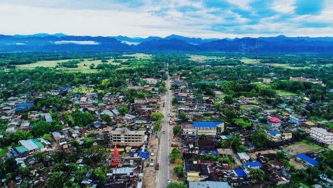
Dhemaji at a Glance
| Detail | Information |
| Role | Headquarters of Dhemaji district |
| Commercial hub of the district | Silapathar |
| Location | North bank of the Brahmaputra |
| Main flood rivers | Jiadhal (“Sorrow of Dhemaji”) and Gainadi |
| Railway station | Dhemaji (DMC), about 2 km from the district HQ |
| Railway line | Rangiya–Murkongselek |
| Highway | NH 15, towards Lahoal via the Bogibeel Bridge |
| Nearest airports | Lilabari (about 66–69 km), Dibrugarh (about 79–80 km), Pasighat (about 128 km) |
Living With Floods
- Jiadhal River: Rises in the Arunachal Pradesh hills, flows through Dhemaji district, takes the name Kumotiya from Gogamukh and joins the Subansiri. It’s called the “Sorrow of Dhemaji” because of the damage it causes.
- Gainadi River: Another river that causes major flooding.
- Impact: Floods destroy much of the district’s crops every year, and many families spend part of the monsoon in relief camps.
- Worst months: June to September. Check the Assam State Disaster Management Authority’s updates before travelling during this period.
Getting to Dhemaji Town, Assam
By Rail
- Dhemaji station (DMC): 2 platforms and 3 tracks, about 2 km from the district headquarters.
- Connections: Trains run to Guwahati, Murkongselek and Tinsukia. One guide also mentions connections to Siliguri and Delhi.
- Division: Wikipedia places the station in the Tinsukia railway division, while the district website says Rangiya. It’s on the Rangiya–Murkongselek line either way.
- Other stations in the district: Bordoloni, Jiadhal, Moridhal, Sripani, Sisibargaon, Silapathar, Dipa, Telam, Laimekuri and Murkongselek, among others.
By Road
- NH 15: Passes through Dhemaji and continues towards Lahoal and Dibrugarh via the Bogibeel Bridge.
- Bogibeel Bridge: Connects Dhemaji with Dibrugarh by both road and rail across the Brahmaputra.
By Air
- Lilabari Airport (North Lakhimpur): About 66–69 km away.
- Dibrugarh (Mohanbari) Airport: About 79–80 km away, with the most flights. One travel blog says 120 km, but official and other sources agree on around 80 km.
- Pasighat Airport (Arunachal Pradesh): About 128 km away, useful for the Jonai area.
Nearby Areas
Silapathar
Described as the district’s most developed town and its commercial centre, with several colleges and busy markets.
Jonai and Murkongselek
- Murkongselek: Described as the easternmost railway station on the Northeast Frontier Railway and on Indian Railways.
- Future rail link: A Murkongselek–Pasighat–Tezu–Rupai line is being undertaken as a strategic project.
- Poba Reserve Forest: On the banks of the Brahmaputra near Tinmile Ghat, with ferries to Dibrugarh.
Bogibeel
Across the bridge from the Dibrugarh side, Bogibeel is now a popular stop for visitors who want to see the Brahmaputra and the bridge up close.
Pasighat
Across the border in Arunachal Pradesh, about 37 km from Murkongselek station. It’s one of the oldest towns in Arunachal and has its own airport.
Education
Dhemaji has several colleges, including Dhemaji College, Dhemaji Girls College, Pachim Dhemaji College, Dhemaji Engineering College and Dhemaji Polytechnic.
FAQs
Q1. What does Dhemaji mean?
A. Sources differ. Tai Ahom reads it as “old village,” while the Deori-Chutia reading, “Dema-ji,” means “great water,” a reference to the district’s frequent floods.
Q2. Why is the Jiadhal River called the Sorrow of Dhemaji?
A. It is called the “Sorrow of Dhemaji” because of the heavy damage caused by its annual floods and erosion to farmland and homes across Dhemaji district.
Q3. How far is Dhemaji from Dibrugarh Airport?
A. Dhemaji is about 79–80 km from Dibrugarh Airport via the Bogibeel Bridge. Lilabari Airport near North Lakhimpur, about 66–69 km away, is slightly closer.
Q4. Which is the easternmost railway station in India?
A. Murkongselek, located in the Jonai area of Dhemaji district, is regarded as the easternmost railway station in India. A new railway line from Murkongselek towards Pasighat, Tezu, and Rupai is planned as a strategic project.