
Model Town, Delhi, almost became the capital of India. In 1912, the Delhi Town Planning Committee’s first choice for New Delhi was this land north of Shahjahanabad, because it connected naturally to the old city and to Civil Lines. The plan moved to Raisina Hill instead, partly because acquiring land here would have cost too much.
What came up here eventually was a neighbourhood rather than a capital. Model Town is one of North Delhi’s oldest planned residential colonies. It has a metro station inside its boundaries, a lake at its centre and Delhi University a short ride away. Here is how the locality is laid out, how it connects to the rest of Delhi, and what lies around it.
Model Town at a Glance
| Detail | Information |
| Revenue district | Central North Delhi (since the December 2025 reorganisation) |
| Sub-colonies | Model Town I, II and III |
| PIN code | 110009 |
| Lok Sabha seat | North Delhi |
| Assembly seat | Model Town |
| Developer | DLF (then Delhi Land and Finance) |
| Metro | Model Town station, Yellow Line (opened 4 February 2009) |
| Landmark | Naini Lake, about 6.5 acres |
A Colony Built Before Delhi Had a Master Plan
Model Town was built in the early 1950s by DLF, then called Delhi Land and Finance, and it is among the first privately developed neighbourhoods in Delhi. The same company is now closely associated with Gurugram’s skyline, so it may surprise newer residents that one of its first projects was a colony of bungalows in North Delhi.
Town planning in this part of the city came from the same tradition that shaped New Delhi and Civil Lines. That approach favoured low-rise houses on large plots with limited ground coverage, and you can still see it on the wider inner lanes today.
The locality has three sub-colonies: Model Town I, II and III. Most residents identify by block and phase rather than by the colony name, so a delivery rider will usually ask “which phase?” before anything else.
The District Change You Might Have Missed
Older documents list Model Town under North West Delhi or North Delhi. That changed recently. In December 2025, the Delhi government notified a reorganisation that increased the number of revenue districts from 11 to 13, and Model Town was placed in the new Central North district. The new boundaries match MCD zones, which should simplify property paperwork and complaint handling.
The Neighbours That Shape Daily Life
You can’t really describe Model Town without the areas around it, because residents move between them all day.
GTB Nagar and Kingsway Camp
Immediately to the south is GTB Nagar, historically known as Kingsway Camp. After Partition it hosted Delhi’s largest refugee camp, with around 300,000 people. Today it is dense, full of students, and very close to Delhi University. Many Model Town families rent out upper floors to this student population.
Mukherjee Nagar
Mukherjee Nagar is next door and is known across India for its civil services coaching centres. Its food stalls, stationery shops and PG accommodation spill into the edges of Model Town, especially along the stretch towards the Outer Ring Road.
Azadpur and the Mandi Belt
Azadpur lies to the north-west. It has an interchange metro station and Asia’s largest fruit and vegetable mandi (commonly described that way, though we couldn’t verify a current ranking). The mandi’s early-morning truck traffic is something Model Town residents on the GT Karnal Road side live with daily.
Gujranwala Town, Derawal Nagar and Kirpal Bagh
These smaller colonies border Model Town on the west and south-west. Their names reflect Punjabi refugee roots: Gujranwala and Dera Ismail Khan (the source of “Derawal”) are towns in present-day Pakistan. Each has its own market, and locals often treat them as extensions of Model Town.
Chhatrasal Stadium
Chhatrasal Stadium is a short walk from Gate 4 of Model Town metro station, alongside Gujranwala Town. It is best known for its wrestling akhara, which has produced several Olympic wrestlers.
How Model Town, Delhi Connects to the Rest of the City
The Metro Does Most of the Work
Model Town station on the Yellow Line is elevated, opened on 4 February 2009, and sits between Azadpur and GTB Nagar. Its gates are useful to know:
- Gate 1 leads towards Alpana Cinema and Model Town II.
- Gate 2 leads towards Tagore Park and Malikpur village.
- Gate 3 leads towards Kirpal Bagh.
- Gate 4 leads towards Gujranwala Town and Chhatrasal Stadium.
| Destination | Stops from Model Town | Line / Change |
| Azadpur | 1 | Yellow; change here for Pink Line |
| GTB Nagar | 1 | Yellow |
| Vishwavidyalaya (DU North Campus) | 2 | Yellow |
| Civil Lines | 4 | Yellow |
| Kashmere Gate (ISBT) | 5 | Yellow; change for Red and Violet |
Heading south, the Yellow Line continues without a change through Chandni Chowk, New Delhi and Rajiv Chowk before going on to Gurugram. For the west or east of the city, take one stop to Azadpur, where the Yellow and Pink Lines connect through a concourse and foot overbridge.
A Second Metro Line Is on the Way
This is the most significant connectivity change in Model Town for many years, but it hasn’t happened yet.
The Magenta Line’s Phase IV stretch from Deepali Chowk to Majlis Park opened on 8 March 2026. The next section, Majlis Park to RK Ashram Marg, is still under construction and is expected in late 2027. It includes a new Azadpur interchange and an underground station at Derawal Nagar, right on Model Town’s western edge.
Delhi Metro projects have missed deadlines before, so treat late 2027 as a target rather than a certainty. When it opens, however, residents on the Derawal Nagar side will be one ride from Sadar Bazar and a Red Line interchange at Pul Bangash.
Roads and Buses
Model Town is connected by the Ring Road and has access to the Outer Ring Road. GT Karnal Road runs along its western side and is the main road route towards Azadpur and further north.
Bus services are extensive. DTC routes serving the metro station include the 100 series, 169, 171, 191, 402, 901 and 971. There is usually a bus even when the metro is packed.
Naini Lake: Worth a Visit, but Work Is Underway
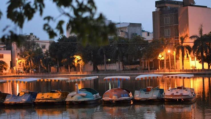
Naini Lake is named after the lake in Nainital. Delhi Tourism lists it as a 6.5-acre water body with boating, a central fountain and ducks, with a listed charge of ₹130 and seasonal hours (1 pm–8 pm from April to September, 11 am–6 pm from October to March).
The lake has also had serious problems. Residents campaigned for years after mass fish deaths, algae and foul smells, which were blamed on concrete cutting off rainwater from reaching it.
A proper fix has now begun. In August 2026, the MCD started a ₹9.73-crore rejuvenation project under AMRUT 2.0. It will pipe treated water from the Coronation Pillar STP into the lake and add musical fountains and lighting, with completion targeted for July 2027. So the lake currently supplied from a sewage treatment plant is being revived using water from a site linked to the Delhi Durbars, near where the capital was almost built.
Because construction is ongoing, boating hours may be irregular. Call DTTDC before planning a family outing around it.
Living Here: A Few Practical Notes
Model Town suits people who want an established neighbourhood rather than a new one. Trees are mature, the metro is within walking distance of most blocks, and DU is two stops away.
The downsides mostly come from the surroundings. Mandi traffic on the Azadpur side, crowding from coaching centres towards Mukherjee Nagar and rush-hour congestion on GT Karnal Road can make short trips take a surprisingly long time. For a quieter home, look in the inner blocks of Model Town I and III rather than on the main roads.
FAQs
Q1. Which metro station is nearest to Model Town, Delhi?
A. Model Town station on the Yellow Line is within the locality itself. Azadpur is one stop north and connects to the Pink Line, and GTB Nagar is one stop south.
Q2. Is Model Town close to Delhi University?
A. Yes. Vishwavidyalaya station at North Campus is just two stops away on the Yellow Line, which is why many students rent rooms in and around Model Town.
Q3. Which district is Model Town in now?
A. Since the December 2025 reorganisation, Model Town has been part of the Central North revenue district, which was created so revenue boundaries match MCD zones.